El Niño is no longer only a forecast. Since our May analysis of the possible 2026–27 El Niño, oceanic and atmospheric conditions across the Pacific have strengthened sufficiently for official agencies to confirm that El Niño is underway. That makes the El Niño cashew crop outlook more important for buyers, processors and traders.
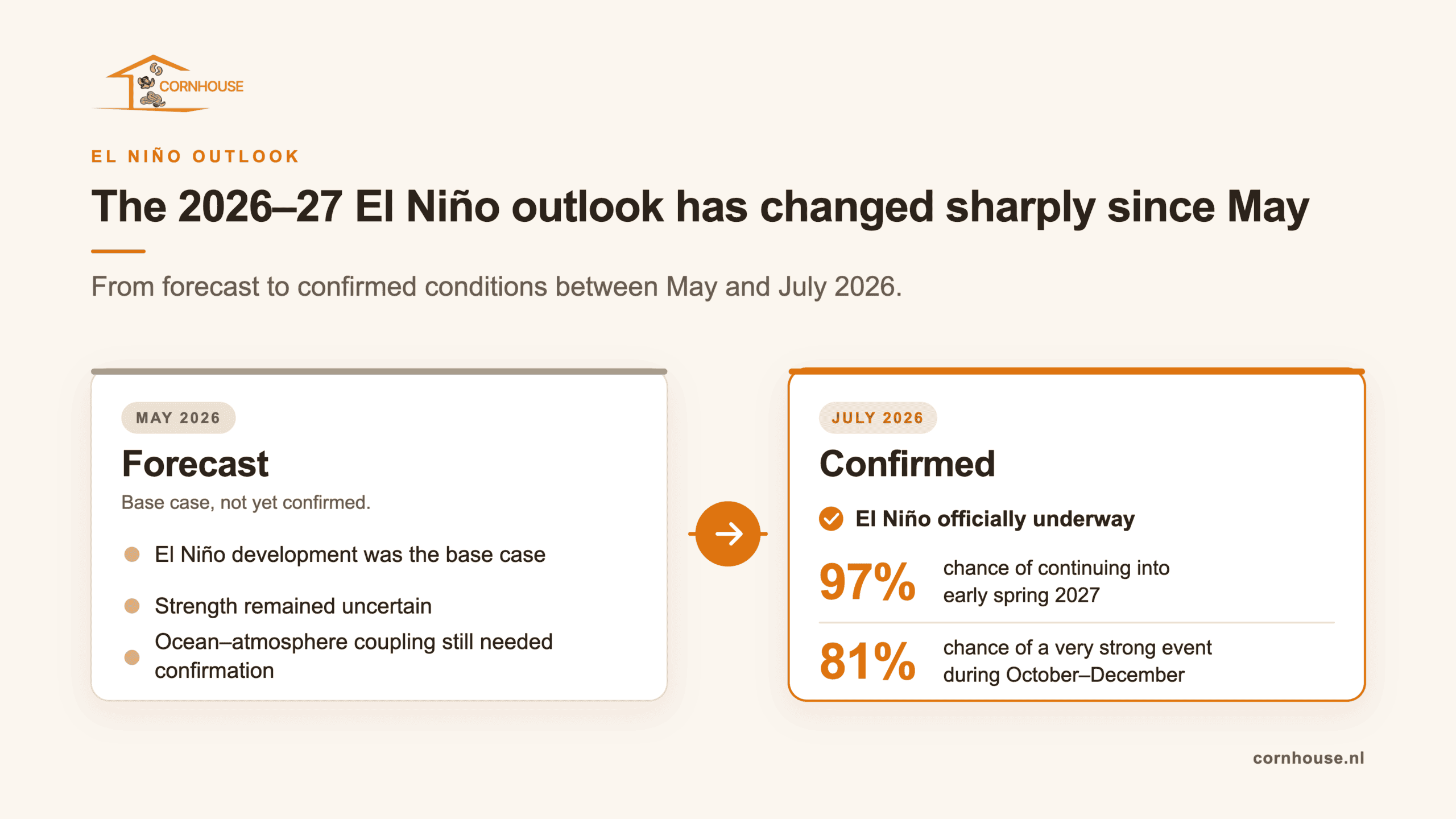
The probability of an unusually strong event has also risen sharply. NOAA now assigns an 81% chance to a very strong El Niño during October–December 2026 and expects the event to persist into early spring 2027.
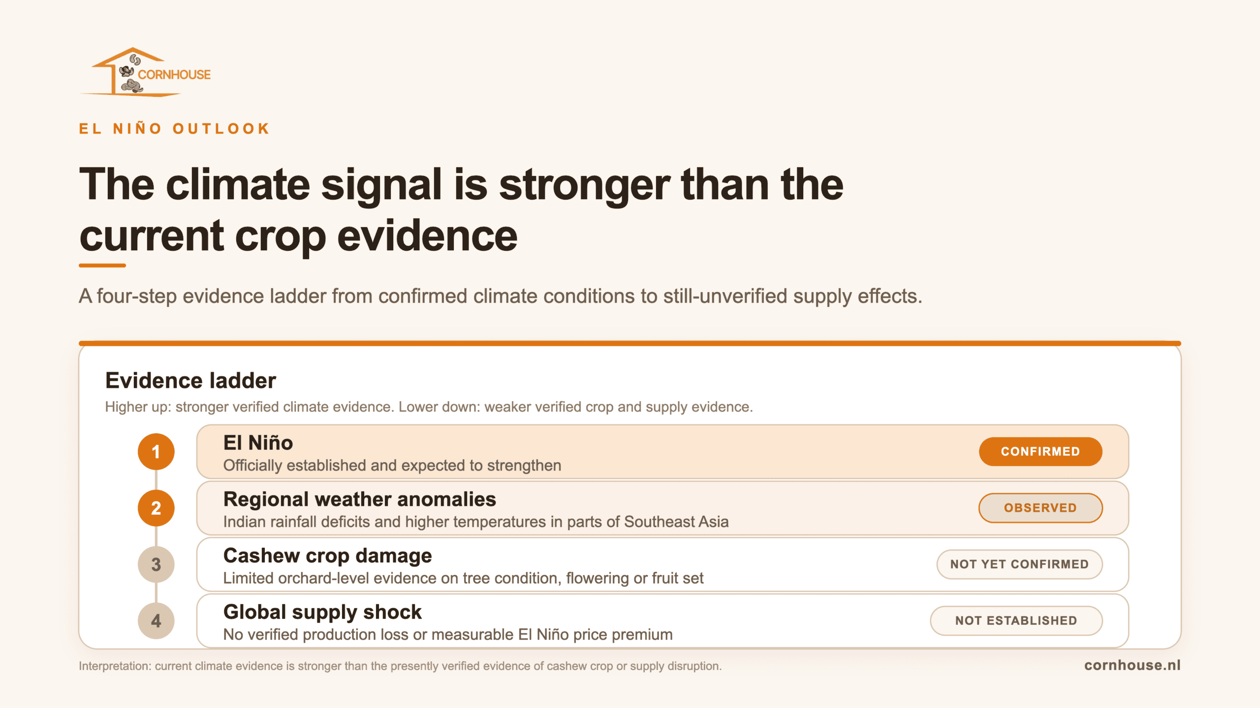
For the cashew market, this is a meaningful change. India has recorded a substantial monsoon rainfall deficit, while parts of Southeast Asia have experienced below-average rainfall and higher temperatures. However, these developments still do not demonstrate that cashew production has been damaged or that a global raw cashew nut supply shock is developing.
The risk has increased. The crop evidence has not yet caught up.
From forecast to confirmed El Niño
In May, the main question was whether El Niño would develop and, if it did, how strong it might become. Official forecasts already showed a high probability of development, but ocean-atmosphere coupling still had to strengthen before the event could be considered fully established.
That first uncertainty has now been resolved.
NOAA reported on 9 July that El Niño had strengthened during the previous month. The organisation identified a large area of sea-surface temperatures more than 1°C above average across the central and eastern equatorial Pacific, together with strong coupling between the ocean and atmospheric circulation.
NOAA now expects El Niño to strengthen through the end of 2026 and gives it a 97% chance of continuing into early spring 2027.
The Australian Bureau of Meteorology has reached a similar conclusion. It reported that trade winds, cloud patterns, atmospheric pressure and the Southern Oscillation Index were all behaving consistently with El Niño. Most of its models indicated that the event could become strong to very strong and potentially peak among the largest recorded since 1950.
The World Meteorological Organization’s multi-model ensemble also shows a rapid intensification. For July–September 2026, it forecasts an average Niño 3.4 anomaly of approximately 2°C, with relatively narrow model spread and therefore higher forecast confidence than earlier in the year.
A very strong event is now likely, but its impact is not predetermined
The strength outlook has changed more than any other part of the forecast.
NOAA’s probabilistic strength forecast now assigns an 81% chance to a very strong El Niño during October–December 2026. Such an outcome would place the event among the largest in the historical record that begins in 1950.
This makes the extreme scenario discussed in May considerably more credible. It still does not mean that a “Super El Niño” has been formally declared. NOAA communicates through weak, moderate, strong and very strong categories rather than using “super” as an operational classification.
More importantly, the strength of the Pacific anomaly does not directly determine the scale of the agricultural impact in every region. NOAA explicitly cautions that even the strongest El Niño events do not produce their typical effects everywhere. A strong event shifts the probability of particular weather outcomes; it does not guarantee drought, excessive rainfall or crop failure in a specific cashew-growing area.
The market therefore has stronger grounds to prepare for weather disruption, but not to assume production losses before they appear in field and crop data.
India’s monsoon deficit is now an observed risk
India provides the clearest example of a weather risk that has moved beyond the forecast stage.
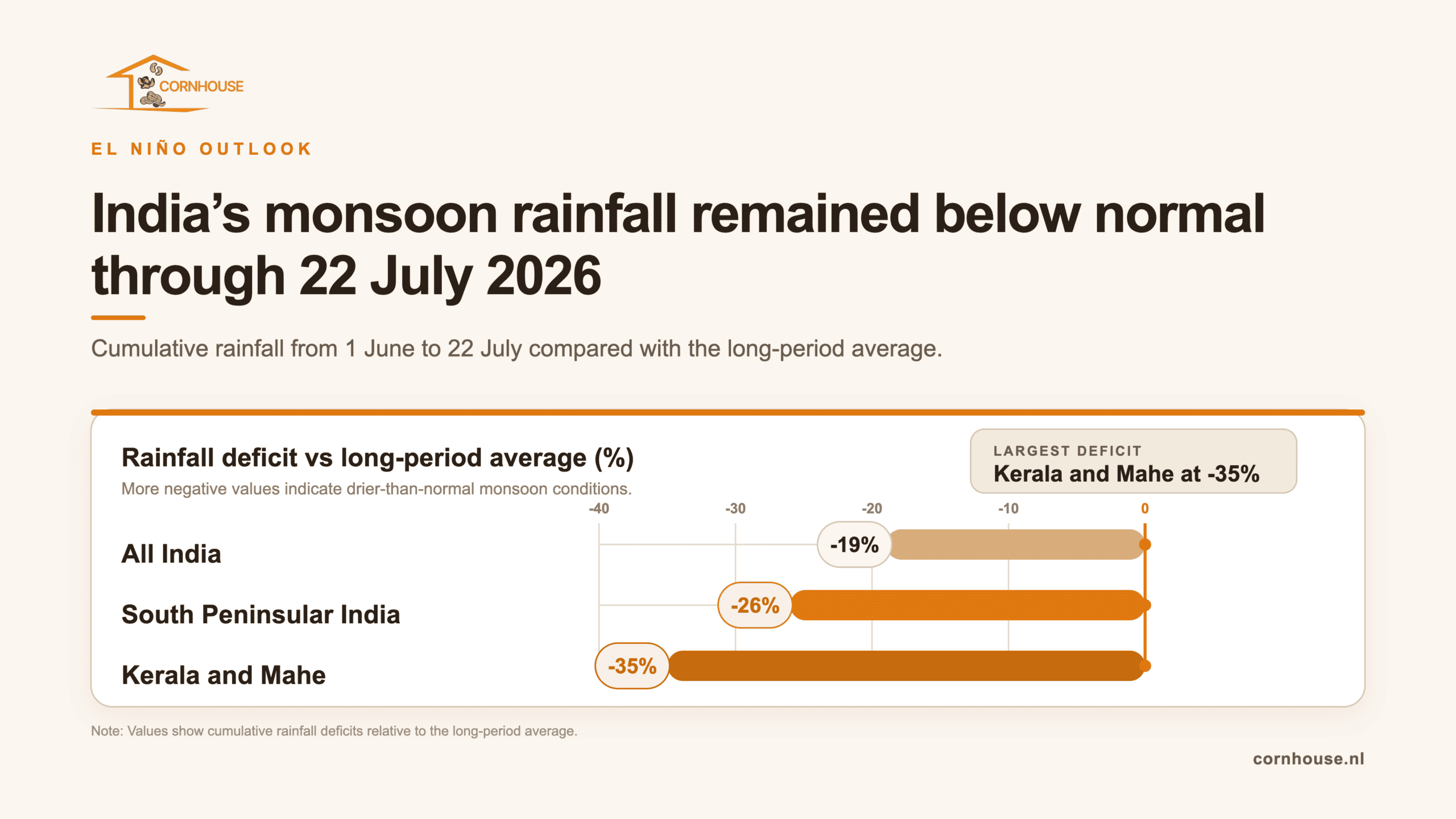
According to the India Meteorological Department, cumulative rainfall across the country from 1 June to 22 July was 19% below the long-period average. The deficit in South Peninsular India was 26%, while rainfall in Kerala and Mahe was 35% below normal over the same period.
These figures matter because several of India’s traditional cashew-producing areas are located in the southern and western parts of the country.
The deficit has not developed evenly. During the week from 16 to 22 July, rainfall across India as a whole was only 1% below normal, although South Peninsular India remained 26% below average. The monsoon can still recover partially during the remainder of the season, and local rainfall distribution will matter more to individual orchards than the national average alone.
The India Meteorological Department had already forecast below-normal rainfall for July across much of the country, alongside above-normal maximum temperatures in most regions. It also expected El Niño to strengthen during the southwest monsoon season.
This is a genuine downside risk for India’s next cashew crop, but it is not yet a production estimate. Cashew trees normally undertake much of their vegetative growth during the wet season before moving towards flowering and fruit development. Whether the current deficit affects production will depend on its duration, soil-moisture conditions, orchard management and the weather during the later flowering and fruit-setting stages.
The defensible conclusion is therefore that India’s crop risk has increased, not that the crop has already failed.
Southeast Asia is warmer, but the rainfall picture remains mixed
Vietnam and Cambodia remain central to the cashew-market implications of El Niño, but the available evidence is more mixed than the Indian monsoon data.
The ASEAN Specialised Meteorological Centre reported that eastern parts of Mainland Southeast Asia received below-average rainfall during June. It also recorded temperatures 1–2°C above average in parts of central Vietnam.
For July–September, ASMC expects El Niño to strengthen and above-normal temperatures to affect most of the ASEAN region. However, its rainfall outlook for northern ASEAN, which includes most of Mainland Southeast Asia, contains a mixture of below- and above-normal signals rather than one uniform drought forecast.
ASMC also notes that model skill is relatively low over parts of southern and eastern Mainland Southeast Asia. That limitation is important when translating a regional seasonal outlook into a view on specific cashew-growing provinces.
The latest shorter-term outlook, covering 20 July to 2 August, predicted warmer-than-usual temperatures across most of southern Mainland Southeast Asia. The clearest dry signal was concentrated farther south in the equatorial and southwestern Maritime Continent, rather than presenting a uniform drought signal across Vietnam and Cambodia.
The Southeast Asian evidence therefore supports closer monitoring of heat, rainfall distribution and soil moisture. It does not yet support a claim that Vietnam’s or Cambodia’s cashew production potential has materially declined.
The next crop cycle matters more than the crop already harvested
Timing is critical when interpreting the current event.
Official Cambodian agricultural documentation indicates that the country’s cashew harvest usually begins in February and continues until the end of May. Most of the 2026 Cambodian crop had therefore already been harvested by the time El Niño became fully established during June and July.
This limits how much of the current Pacific development can reasonably be blamed for the crop that has already entered the market.
The more important question is what the developing event means for the next production cycle. Cashew trees use the wet season for vegetative growth, followed by a period leading into flowering and fruit formation. Flowering itself can last 30–60 days, with fruit maturation requiring a further 70–130 days.
Persistently high temperatures or inadequate rainfall during vegetative development could weaken the foundation for the next crop. Later, overly dry conditions during flowering and fruit setting could reduce production, while excessive rain during flowering could increase disease and flower-loss risks.
This makes the 2027 Asian crop the more meaningful test of the current El Niño event. The coming months will show whether the weather anomalies remain broad climate signals or begin to affect tree condition, flowering potential and field expectations in specific origins.
No confirmed cashew supply shock
The official climate outlook is now more serious than it was in May, but several conclusions remain unsupported.
There is not yet sufficient evidence to state that:
- Vietnam or Cambodia will produce a smaller 2027 crop;
- India’s monsoon deficit will result in a defined production loss;
- West African flowering or fruit setting has been adversely affected;
- Tanzania, Mozambique or Brazil will experience lower cashew output;
- higher Vietnamese or Indian raw cashew nut imports are being caused by El Niño;
- current RCN or kernel prices contain a measurable El Niño premium.
Weather forecasts and regional anomalies are not crop assessments. Production losses require evidence from rainfall in the actual growing areas, soil moisture, tree condition, flowering, fruit set, pest and disease pressure, harvest expectations and eventually arrivals.
The absence of confirmed losses does not make the weather risk irrelevant. It means the market should distinguish carefully between a stronger climate warning and an established change in supply.
What you should monitor next
The most important indicators over the coming months are now more specific than they were in May.
In India, attention should remain on the evolution of the southwest monsoon, particularly rainfall and soil moisture in the southern and western producing areas.
In Vietnam and Cambodia, the relevant signals will shift from general regional rainfall towards local heat, water availability, vegetative growth and later flowering conditions.
NOAA’s monthly strength forecasts will show whether the very strong scenario remains dominant as the event approaches its expected peak.
Across Africa and Brazil, country-specific rainfall and crop-stage information will be needed before drawing commercial conclusions from the global El Niño label.
For the market itself, Vietnam’s and India’s RCN import pace, African origin availability, quality, outturn, farmer selling and shipment timing will remain at least as important as the climate forecasts.
Conclusion: Why the El Niño cashew crop outlook matters more now
The El Niño risk discussed in May has become more concrete. The event is now established, ocean-atmosphere coupling has strengthened and a very strong peak is the most likely outcome in NOAA’s latest forecast.
India’s monsoon deficit and warmer conditions in parts of Southeast Asia provide the first regional warning signals relevant to cashew markets. But they do not yet prove that cashew crops have been damaged.
The main change is therefore not a confirmed shortage. It is a higher probability that weather will become an important market factor during the next crop cycle.
For buyers, processors and traders, the right response remains measured. The 2027 Asian crop deserves closer monitoring, particularly as trees move from wet-season development towards flowering and fruit setting. Crop assessments, local weather observations and RCN availability will determine whether the present climate risk eventually becomes a supply and price story.

 We use cookies to ensure you get the best experience on our website. For more information, please read our